


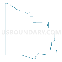
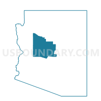
Coffee Pot Voting District, Yavapai County, Arizona
About
Outline

Summary
| Unique Area Identifier | 525770 |
| Name | Coffee Pot Voting District |
| County | Yavapai County |
| State | Arizona |
| Area (square miles) | 3.45 |
| Land Area (square miles) | 3.45 |
| Water Area (square miles) | 0.00 |
| % of Land Area | 100.00 |
| % of Water Area | 0.00 |
| Latitude of the Internal Point | 34.88086630 |
| Longtitude of the Internal Point | -111.80892760 |
Maps

Graphs
Select a template below for downloading or customizing gragh for Coffee Pot Voting District, Yavapai County, Arizona


Neighbors
Neighoring Voting District (by Name) Neighboring Voting District on the Map
- Red Rock 1 Voting District, Yavapai County, AZ
- Red Rock 2 Voting District, Yavapai County, AZ
- Red Rock East Voting District, Yavapai County, AZ
- Red Rock West Voting District, Yavapai County, AZ